From the coastal region we headed inland to the central Highlands of the Grampian Mountains along the Spey River of whiskey fame.
What is it? Found on the shores of a small Loch. At the time we thought it to be a natural stone but may have been the bowl for a pestal.
A decent place to sit at the Cairn Gorm Visitor centre near Aviemore.
A bleak and rugged landscape on the higher land of the Cairngorm Mountains, central to the Cairngorms National Park.
There is an easier way to climb a Munro. What are we on about? A Munro, for the mountain (hill) climbing fraturnity in the UK, is any elevation (a mountain to the British) above 3000 feet (917m). It is a national pastime for the rugged outdoors type to notch up how many they have climbed and in this region there are a number of tops over 3000 feet. The cable car, on the left, takes about 9 minutes to carry passengers nearly to the top of Cairn Gorm Mountain 1245m. In winter it takes skiers.
A general view of the landscape near the top where there is a visiter centre and viewing platforms around the building.
Another view. The hills are all well weathered and round topped with few rocky escarpments.
Down the funicular railway (cable car) and back on the road a visit to this small Loch and forest walk area not far away.
The gallery is a restored and well maintained cottage.
With a very authentic slate roof seen here complete with moss.
No discussion of the highlands would be complete a look at heather, seen here in full bloom near Dalwhinnie, a few miles south west of Aviemore below Loch Ericht. We were lucky to be able to rent a "self catering" cottage here for a week to explore the area.
The eroded granite rock leaves lots of water pools near and in small streams.
There are also pockets of cultivated grassland grazed mostly by highland black face sheep.
Although these were found on more rugged territory nearby.
We took a drive down the valley of Loch Laggan and the Gen Spean whihc is the home of the great house in the TV series Monarch of the Glen. On the left the gate keepers cottage and bridge entry to the property.
A full view of he cottage with its tower that would have been the first part built as a defensive post.
The house was only visible in the distance across the Loch.
In all other respects the Glen is rather bleak yet has its own charm.
The words "military road" show on various maps. This one the Wade military road originally built in the mid 1700's, at Spean Bridge, near Fort William, one time a rail line and now a walking track. It is in an area since used for military taininng and there is a major memorial to the Commandos who trained in this location of Spean Bridge. At this location we had actually linked with our route north going through Fort William and Spean Bridge on our way down Loch Ness.
The Spean River showing old bridge abbutments.
Rail is an important transport and these trains frequently passed through Dalwhinnie with some even stopping for passengers.
Also frequent freight trains, this one travelling the opposite way only a few minutes after the passenger train.
These older type signals were still in use.
Britain is connected by rail and includes the small village of Dalwhinney. Its claim to fame is where General Montgomery alighted for a few days to ponder his plan for Dunkirk during WW11.
We assume this nonsensal notice was not then in place on the platform when Montgomery alighted. Question. How does one get to the train to ask the conductor?
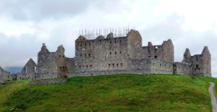
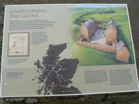
Not far away from our cottage Dalwhinnie is the ruin of the Ruthven Barracks built in the 1700's to accommodate a detachment of the King's troops. It is midway through a major east-west route through the highlands.
The National Trust plaque.
Strengthening and restoration work is being carried out.
It is however just a shell.
If was not for the camera he is holding this character may have been here all the time.
This shows where floor joists were located in the walls to carry various floors in the defensive tower.
The sign says it all. The stables were about 30m from the main building.
The stable outback.
Remains of the stables showing the thickness of the walls.
As it may have once looked on the mound over-looking the valley.
Any tour of Scotland would be incomplete without visiting a distillery all of which encourage tours of the premises and of course the sales room. Dalwhinnie is reputed to be the highest elevation distillery in Scotland near the head of the Truim River which then flows into the Spey River.
The central highlands is very much about lochs, ...
...forests and woodlands, ...
... wetlands, ...
... and with a bit of luck sighting free roaming wildlife...

...and the small wildflowers
Plantation trees on a high plateau with these open lanes between small blocks.
The soils appeared as a water logged clay. Between each second row of trees was a deep trench, now grassed over, which looked to have been created when the trees were planted.
An exclosure plot showing the natural reversion if the land is not grazed by animals.






 ...and the small wildflowers


